Introducing LOJIC On-Demand
Your new, always-available gateway to digital data products!
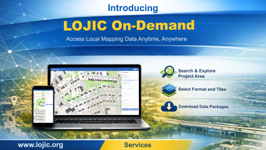
We’re thrilled to unveil LOJIC On-Demand, a streamlined web app designed to make accessing LOJIC data products faster, easier, and more convenient than ever. Whether you’re working late, planning ahead, or managing a project on the go, LOJIC On-Demand is available 24/7 to deliver the data you need—right when you need it.
With an intuitive interface and a simple step by step process, you can browse, select, and purchase data tiles in just minutes.
How It Works
Getting started is quick and straightforward:
1. Open the app in your preferred web browser.
2. Navigate to your project area using the map tools or address search.
3. Select up to 20 tiles using the built in selection tools.
4. Enter your email address for delivery and acknowledge the payment statement.
5. Click “Purchase Tiles.”
6. Provide your billing information and complete checkout.
7. Receive an order confirmation email, followed by a delivery email within 48 hours containing your download link.
LOJIC On-Demand is built to give you control, flexibility, and immediate access to the data that powers your work. It’s a new chapter in how we deliver digital products—and we can’t wait for you to experience it.
About the Data
If you cannot find the data you need from the LOJIC Open Data Portal, you can extract and convert data for specific project areas to AutoCAD and Esri shapefile formats for a fee using LOJIC On-Demand.
This digital data product includes planimetric and topographic base map data for Jefferson County. Data with an asterisk (*) is also available for Bullitt and Oldham Counties.
LiDAR can be downloaded for free from our LiDAR Grid Interactive Map
Data that can be converted to AutoCAD:
Available GIS data layers

MSD Building
1600 West Hill Street
Louisville, KY 40210
38.2277 N, -85.7810 W
LOJIC Staff is available from 8:15 am to 5:00 pm (EST),
Monday through Friday, to respond to your questions.